Tuesday November 13 2018
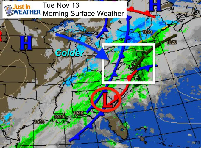
The current storm is moving away, but there will be some rain showers left over this morning. Temperatures will reach their peak around noon, then cool off for the kids getting home and late day commute. Some snow will break out in western Maryland. But fast forward to Thursday and more of us will see snow as the next storm arrives.
At this time it looks like what falls will look more impressive than what may stick. It is early in the season, but the system has followed the trend to arrive earlier. So we get a better chance to act on morning air to break out snow for the arrival. More on that below.
Local Weather Stats For November 13 in Baltimore
Average High: 58ºF
Record High: 77ºF in 1979
Average Low: 37ºF
Record Low: 22ºF in 1911
Sunrise: 6:47 AM
Sunset 4:53 PM
*Daylight = 1:58 shorter than yesterday
*Bay Water Temperature = 53ºF at Thomas Pt. Light House
Rainfall 2018 Total: Rank 3rd Wettest Year
This chart includes rain through midnight. We added more since then… We could get the top spot Thursday or Friday

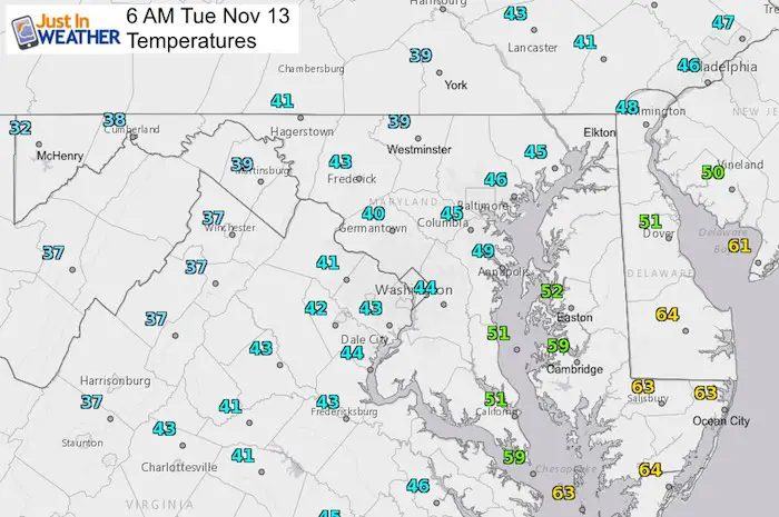
Morning Snapshot
Radar Simulation Today —> slider
Showers this morning. Snow develops in the mountains and one more batch of rain may make it to Hagerstown this afternoon.
[metaslider id=68230]
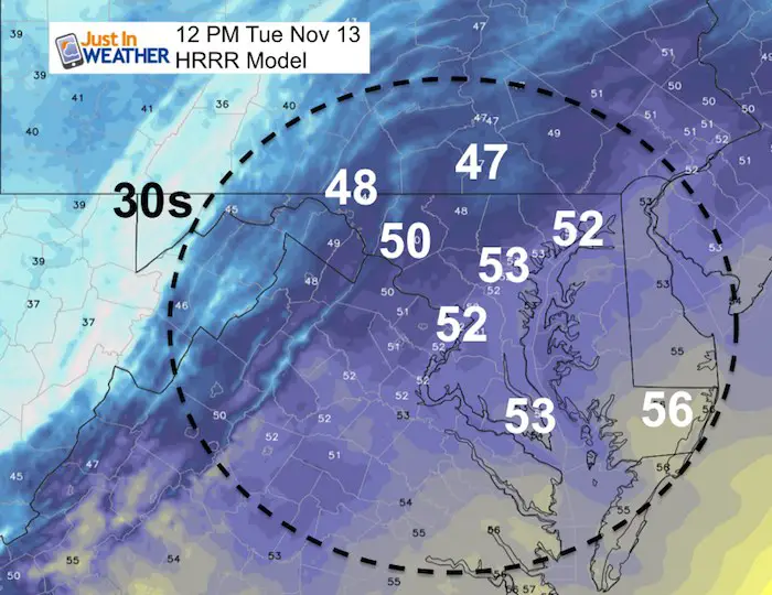
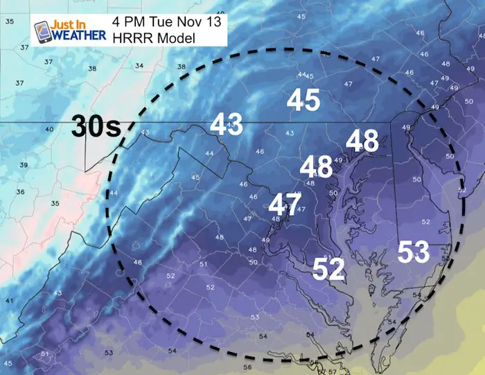
Temperatures
It will be warmer at noon, then cooler by 4 PM
Noon (Highs)
4 PM
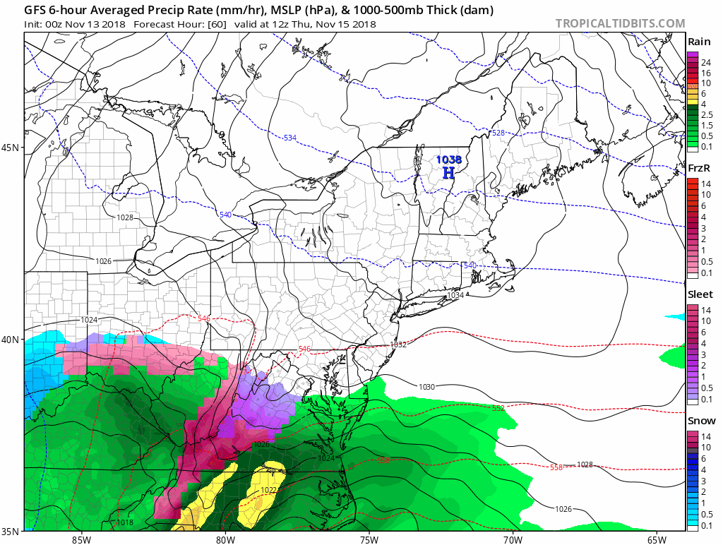
Thursday Coastal Storm
Since this will arrive in the morning, more sleet and snow will be seen.

Radar Simulation Thursday —> slider
The question is stickage? The ground is warm and temperatures may be above freezing while flakes and sleet fall during the day. That will eat into any model showing snow totals. I will elaborate on this during my afternoon report.
[metaslider id=68243]
Storm Animation
The storm will have us on the colder side, but warmer air will move in with rain Thursday evening into Friday morning. This appears to show a secondary Low forming right along the Delmarva coast as the initial Low moves out to sea.
How Much Snow?
Warning: I do not trust modeling early in the season. I have seen a lot of maps with large totals, but not all of that can stick. I will do a comparison and update on this during my afternoon update.
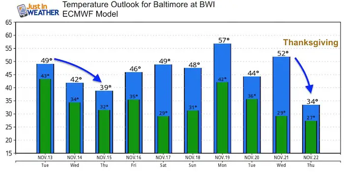
Temperature Outlook
Winter Outlook
My Winter Outlook 2018-19: Multiple Nor’Easters and more snow

Related Winter Outlooks
Solar Cycle: When Sun Spots Are Low We Get More Snow
El Nino Modoki May Enhance Snow Chances
Sweet Spot: Hitting 70ºF on Halloween is followed by more winter snow
Will A Wet Summer Bring A Snowy Winter?
NOAA Winter 2018-2019 Outlook Explained: This Actually Supports Snow
Winter Outlook From Two Different Farmers Almanacs
FITF and SnowStix Stores are now OPEN

Snowstix- We Need You To Measure Snow Too
We are giving 10% of each sale to Just In Power Kids: Providing FREE holistic care for pediatric oncology patients.

Keep In Touch Every Day
Click here to sign up for email alerts…. Just in case you don’t get the post on your social media feed
Please share your thoughts, best weather pics/video, or just keep in touch via social media
-
Facebook: Justin Berk, Meteorologist
-
Twitter: @JustinWeather
-
Instagram: justinweather