


April 19 Showers Later Today Then Strong Winds Usher In Colder Air Tomorrow
Friday April 19 Morning Report The pattern is about to change. The sunny and mild days we have had will be replaced with a colder-than-average outlook into next week. This…
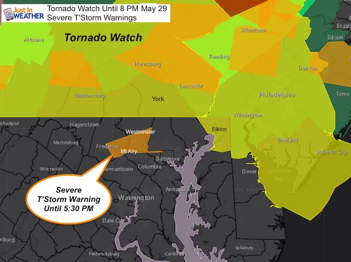
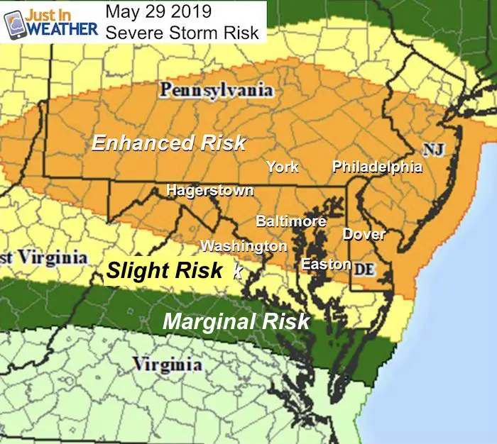
5 PM Wednesday May 29
A Tornado Watch was issued earlier for much of Pennsylvania, Cecil County MD, and northern Delaware. The important issue here is that a recent Severe Thunderstorm Warning was issued in Maryland south of that region to include Frederick and Southern Carroll Counties. That is why Maryland still needs to pay attention as severe storms are trying to form over the next two to three hours without any ‘Watch’ in place.
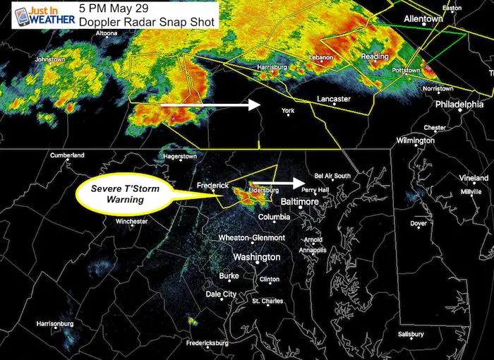
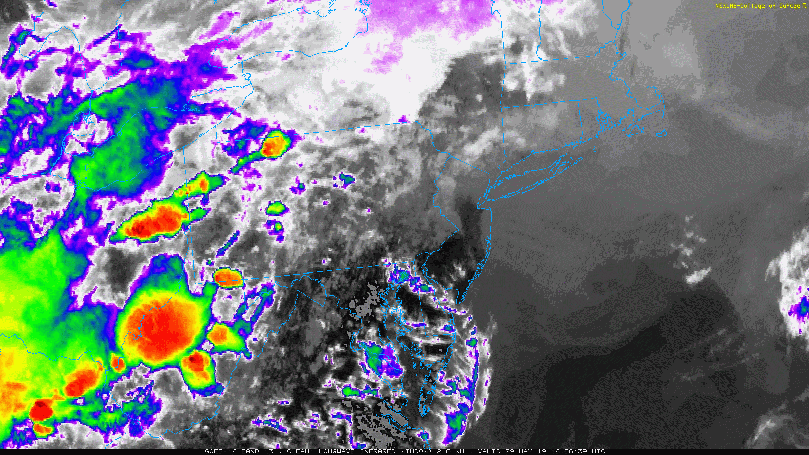
Compare this Advisory map to the Doppler Radar Snapshot and short range modeling below. At the bottom of this post, some very impressive satellite and radar loops of the complex in PA.
Tornado Watch and Severe Thunderstorm Warnings
Doppler Radar SNAPSHOT at 5 PM
This cluster passing through Eldersburg is worth watching as it may trigger a larger line as it interacts with winds from the Bay and passed through Baltimore, Harford, and Cecil Counties.
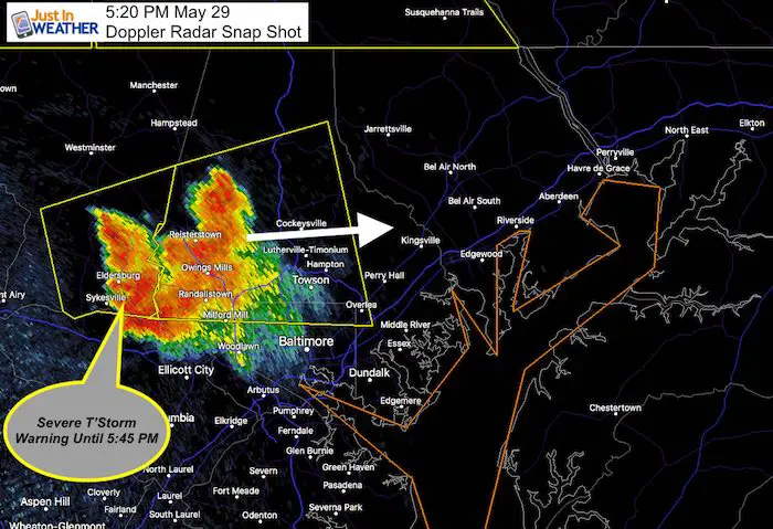
UPDATED RADAR at 5:20 PM
Notice the cell building across Baltimore County. This movement to the east northeast is what I showed in my morning post with this renegade afternoon storms. Then we watch the PA line drop south tonight.
Radar Simulaltion —> slider
The first image was the short term forecast from NAM 3 Km for 5 PM.
The storm in Eldersburg was missing. The second frame at 6 PM seemed to show it, indicating the model was off by 1 hour. So please consider that for the rest of this evenings simulation.
This cell may develop into a line to affect Cecil down through the lower Eastern Shore this evening.

Severe Storm Qualifier:
Please note that as we get closer, these are potential alerts to be issued.
Severe Thunderstorm Watch: A broad area and window with a 4 to 6 hour time frame. This means it MIGHT happen.
Severe Thunderstorm Warning: A focused area like a county usually with a 30 to 60 minute time frame. This means it IS HAPPENING NOW.
Warning: A focused area and time frame. This would list towns in a likely path within a 15 to 45 minute window.
Radar Loop (2 Hours Up to 5 PM)
IR Satellite Loop (4 Hours Up to 5 PM)
Just in case you don’t get all posts on your social media feed, stay up to date with the latest info…
Click here to sign up for email alerts…. Be the first to hear any new weather.
Join My Team: Maryland Trek 6
Our look got an upgrade, but we have the same purpose. Please click the logo take a look at our new page.

Support Our Nonprofit:
Proceeds go to our programs Providing FREE holistic care for kids in cancer treatment and up to 5 years post treatment and caregivers.
![]()
Shine On
Proceeds from all sales go to Just In Power Kids. Click the image to shop and show your support.

Love Maryland Shirts and Hoodies
This shirt was designed by my ‘bonus’ daughter Jaiden. The hoodie has been the biggest hit, so our promotion has been extended until the end of this week.
|
||
|
Show your love for Maryland and make this 14 year old artist and her mom extra proud
|
Please share your thoughts, best weather pics/video, or just keep in touch via social media
Related Links:
Was Your County Not Included?
Click this map for more on the regional forecast zones
