


April 16 Stepping Back From Summer Heat To A Cool And Wet Pattern
Tuesday, April 16 Morning Report Yesterday was sincerely a summer preview! Temperatures did soar as expected into the mid-80s with BWI hitting the mark of 85ºF. This fell short of…
Thursday May 30 2019
As we spend another day with a risk of severe storms, we are waiting for the atmosphere to ignite with heat of the day to trigger storm cells. Two short range model I look at and often share with you are the NAM 3 Km and HRRR. Both of these models have two very different outlooks for how the event may play out later today. I wanted to show you both to compare, so when it develops we will have a better idea of which may be on to something.
Model Notes:
The NAM 3 Km has done the better job this entire month. It is updated every 6 hours.
The HRRR Model is updated every hour with new hourly observations and adjustments to the main model timer frame. But it has had a hard time depicting storm cells and timing. I have fondly called it HRRRible lately. Today, I think it may be on to something… Something more active and worth watching.
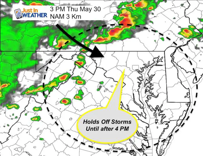
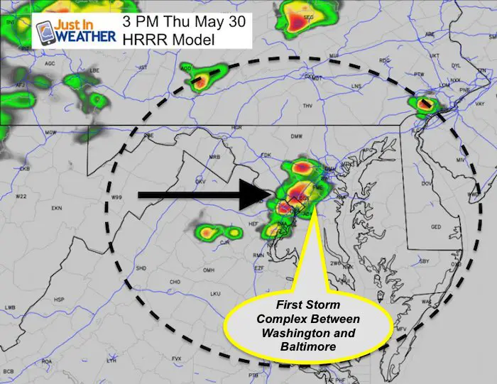
First 3 PM Time Frame
NAM 3 Km
No storms in central Maryland.
Main storm line near I-81 just west of Hagerstown to Harrisburg PA
HRRR Model
This model already has a complex in metro Washington and entering Baltimore. The first of a few.
See the timeline slider for each of these models below, but first I need to reinforce this:
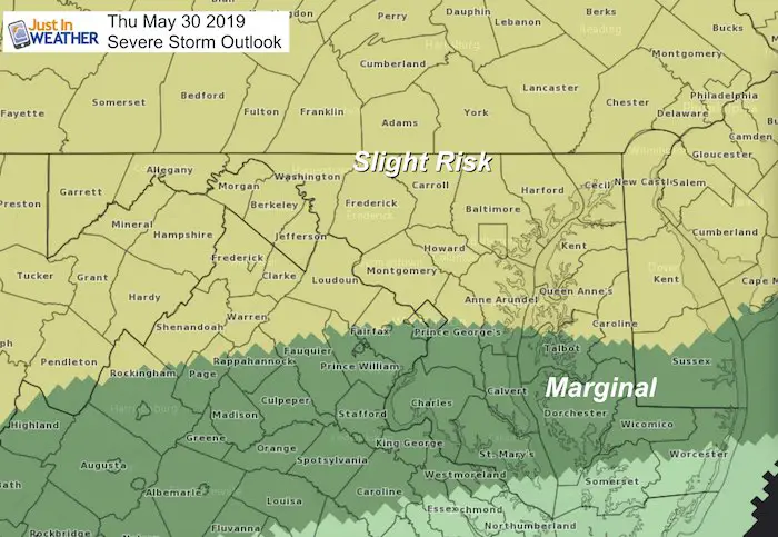
Reminder of today’s Risk areas by county:
Severe Storm Qualifier:
Potential alerts to be issued:
Severe Thunderstorm or Tornado Watch: A broad area and window with a 4 to 6 hour time frame. This means it MIGHT happen. If this is issued, it will likely be posted early after and last until the evening.
Severe Thunderstorm Warning: A focused area like a county usually with a 30 to 60 minute time frame.
Tornado Warning: This means it IS HAPPENING NOW indicated by Doppler Radar or confirmed sighting from the ground. A focused area and time frame. This would list towns in a likely path within a 15 to 45 minute window.
Related Links:
Was Your County Not Included?
Click this map for more on the regional forecast zones

Storm Timeline Comparisons
HRRR Model —> slider

NAM 3 Km Model —> slider

What To Look For:
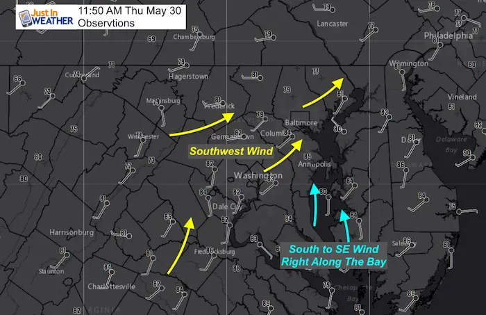
Wind Direction plays a big role for us!
Just in case you don’t get all posts on your social media feed, stay up to date with the latest info…
Click here to sign up for email alerts…. Be the first to hear any new weather.
Join My Team: Maryland Trek 6
Our look got an upgrade, but we have the same purpose. Please click the logo take a look at our new page.

Support Our Nonprofit:
Proceeds go to our programs Providing FREE holistic care for kids in cancer treatment and up to 5 years post treatment and caregivers.
![]()
Shine On
Proceeds from all sales go to Just In Power Kids. Click the image to shop and show your support.

Love Maryland Shirts and Hoodies
This shirt was designed by my ‘bonus’ daughter Jaiden. The hoodie has been the biggest hit, so our promotion has been extended until the end of this week.
|
||
|
Show your love for Maryland and make this 14 year old artist and her mom extra proud
|
Please share your thoughts, best weather pics/video, or just keep in touch via social media