


April 24 Weather: Some Showers Then Another Push Of Cold Air Followed By Summer Heat Sunday
Wednesday, April 24 Morning Report A milder start today with most areas in the 50s to near 60ºF along parts of the Bay. There is a push of colder air…
March 20, 2023
We have turned the corner with the Spring Equinox. By chance I was talking with my friend Jason Smith this morning about something different as he was saying, “live in the season you are in”. I am ready to turn the page, but figured this would be the most appropriate time to recap this past record winter, or as many will know it in our region, “The winter that never was”.
As of this date, Baltimore has only measured 0.2” of snow, marking the lowest snow season on record. This is only the second season below 1 inch since 1950! So a lot of people alive today have never experienced this. It is quite the contrast to the Western US where many are at, or near their most snow on record! We will look at that below as well.
I have some comments I want to share with you before getting into the stats, maps, and charts. I hope my words convey my perspective and even put to rest some of the snarky readers that may think us weather people don’t care. This guy does!
No one knows the future for certain. I have studied the science of the atmosphere and understand how it works. A weather forecast is an educated guess based on information on hand and experience. A seasonal outlook or prognostication is simply a hypothesis expanded to include more history of various patterns mixed with a little bit of a feeling in your gut.
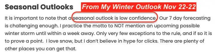
In fact, in my Winter Outlook I stated I had Low Confidence.
Screenshot From My Winter Outlook
It goes without saying that this winter under-performed, but I want to state the obvious:
The word Bust has been overused for weather events and I do believe it is a FOUR-LETTER-WORD, so I will simply acknowledge that and explain my errors and then get into some details.
If this was an exam, I would have failed. But I see each event and season as more exams, so in this course of life I still have a good track record.
I won’t blow this off. I study my mistakes to learn and aim to improve next time.
For the record: I have spoken with my clients that plow snow. I offered all a refund considering the lack of work. They did have some salting events and declined. I have offered to discount next year and I will see if any take me upon it. For now, they all seem to understand, which is not what I can say for any operators I don’t work with, but just read my online reports.
I am NOT the only forecaster nor do I want you to just take my word. I still confer with former colleagues to get more insight into big events.
When I was at Cornell we had an expression: Get 4 meteorologists in a room and end up with 5 different forecasts. It’s that 5th one that is most often the best.
I don’t think anyone expected this little snow, but I know some called for a low snow winter. I commend them!
I also know there were outlooks for a booming, stormy winter. I wrote a report comparing Two Farmer’s Almanacs in early September expecting an exceptionally cold and snowy season. I have always encouraged my readers and friends to get multiple opinions. This report is simply about my call and what happened.
The biggest mistake I made was having the guts to call for a ‘near normal’ winter. I know, right? How dare I expect normalcy (I do hope you hear the sarcasm and feel my grin coming through the screen).
Map from NOAA: National Operational Hydrologic Remote Sensing Center
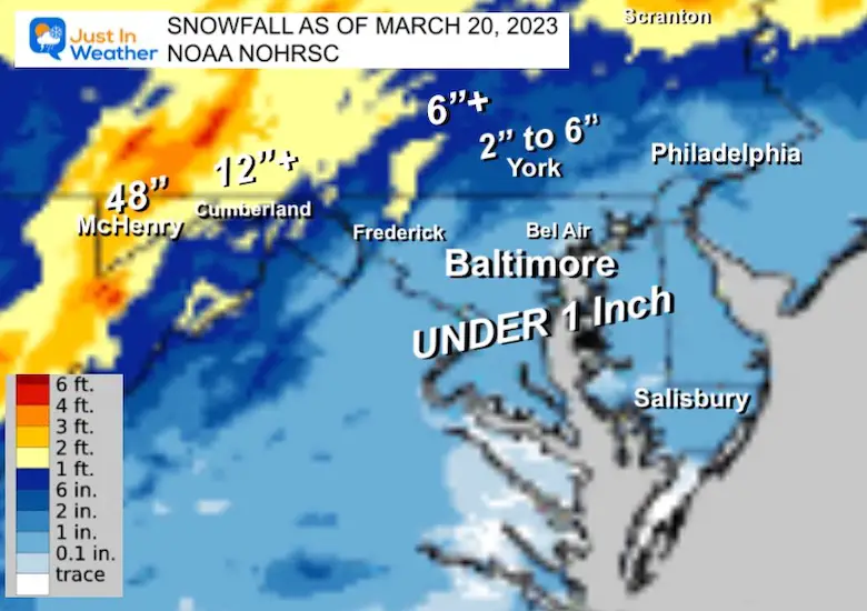
This is the snow map on my Maryland Snow Page
Our regional snow is impacted by proximity to the water of the Chesapeake Bay and Atlantic Ocean, plus hills and mountains that are colder farther west.
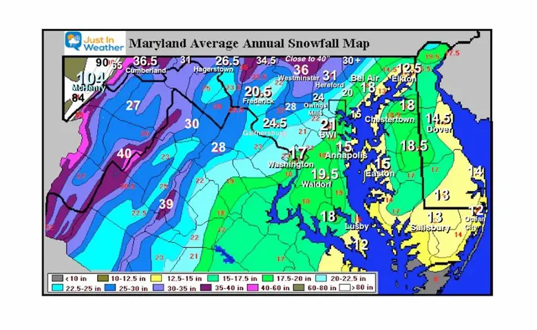
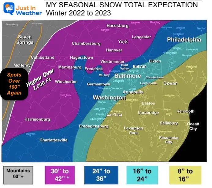
My map was intended to mimic the average expectation, if you compare to the map above. My call for far Western Maryland is now close to 50% of ‘average”, while most of the region ended up with a fraction of a ‘normal’ year.
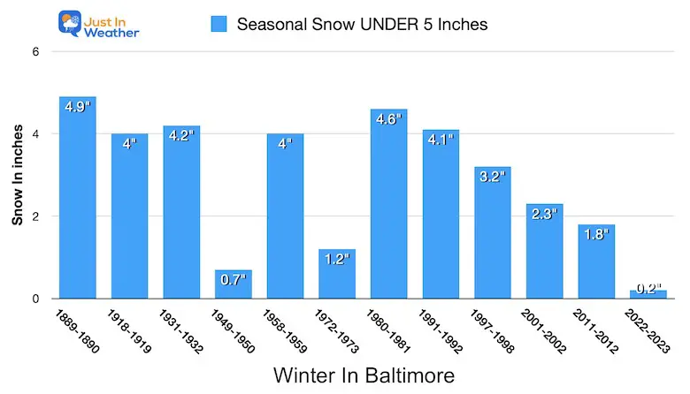
Since 1883 (140 years), there have only been 12 winters with UNDER 5 inches of snow.
Now there are TWO winters with UNDER 1 inch of snow.
CHART
When I look at the Baltimore history of snow, I see the decade of the 1950s had the lowest average snow = 14.6″. People then thought winters had changed. Then the 1960s ended up with the highest average snow = 32.4″ nearly DOUBLE for the decade.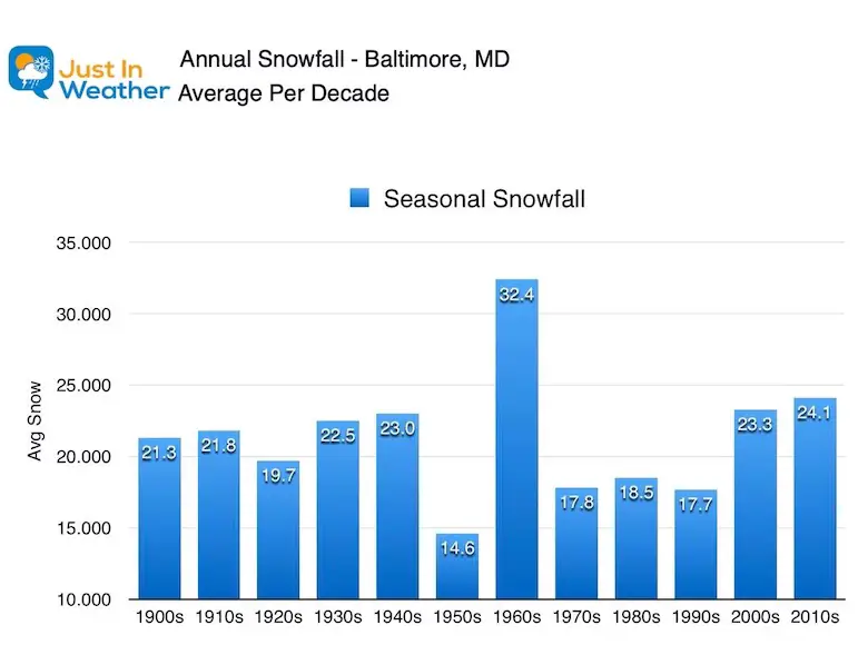
I am not going into the weeds of Climate Change in this report as the expectations widely vary. Simply look at the heavy snow and drought busting rain in California this winter to see that there was plenty of cold and stormy weather, it was just stuck on the other coast.
I based my forecast on this season NOT being governed by La Niña as I expected it to end before the end of winter. It did, as declared by NOAA earlier this month. However, this was the 3rd winter in a row with a La Niña. That was a rare situation and the prior winters were split with results.
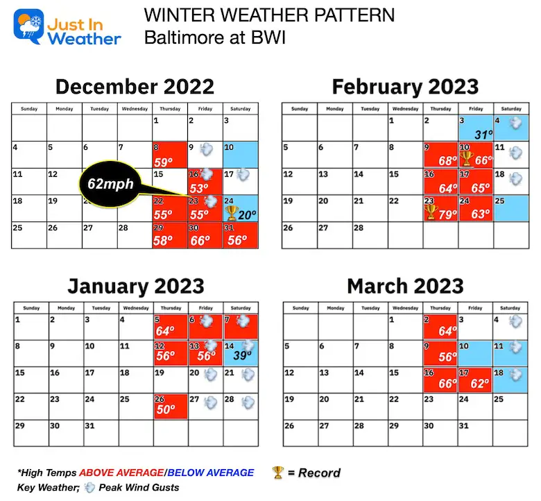
We had a colder start. December ended up below average.
I expected a Mild start to January, but not the very warm 60s we had that first week. Then winter kicking in for the second half of January into March. This last part did not work for us, but if only we were in central PA to New England maybe I could make an argument with their recent snow.
We did have that Polar Vortex disruption just prior to Christmas. That gave us a record cold Christmas Eve Day with a high of 20ºF, but it didn’t last!
I did accurately outperform the model for the little snow we got on February 1.
There were other PV disruptions, but they also were simply a visit for a day or two.
La Niña Ended BEFORE the end of Winter.
Persistence or Atmospheric Memory on Steroids!
That pre-Christmas Flash Freeze did not materialize like I expected. The frigid weekend that followed could have been worse if it did. We got lucky.
This La Niña behaved like an El Niño. The pattern was very active as I suspected, just locked into the other coast. More on that below.
We could not shake or break the warmth. There was plenty of cold air, but we could not get it to establish even with those Polar Vortex Disruptions.
When we got cold air patterns, there was no true arctic air available. We have had some late season storms that under normal conditions would have produced snow. This year, it was just not cold enough, even with storm tracks to our south.
Record Low Afternoon: Dec 24
Record High Temperatures: 66ºF on Feb 10; 79ºF on Feb 23
You may recall this winter began with over 81 inches of snow near Buffalo in Orchard Park back in November. That moved the Bills home game to Detroit before Thanksgiving. Another Extreme Lake Effect Event a month later.
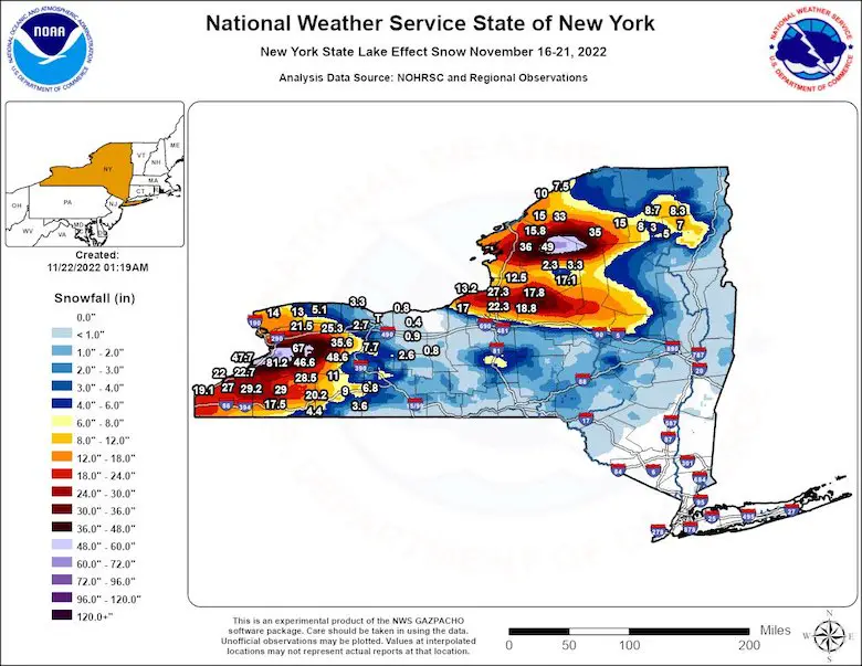
This is real!
I went outside my place for a minute to see two things… feel absolutely awful so seeing this right by the house helps. Im 6’4” for reference and the band from the Skyline in Buffalo…insane. Band drifting back into the city. Goodnight all.. pic.twitter.com/XQvQzSOexE
— Brett Adair (@AlaStormTracker) November 19, 2022
There was more snow in and around Seattle, Los Angeles, Las Vegas, and Dallas than Baltimore and central Maryland.
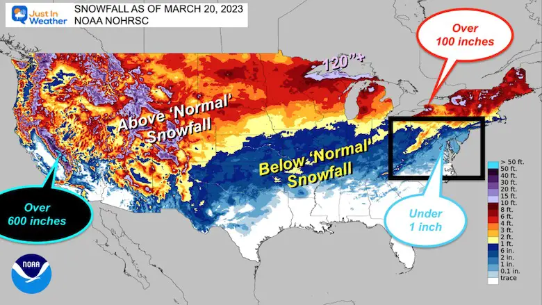
The big winners have been in the Sierra-Nevada Mountains. The UC Berkeley Central Sierra Snow Lab has measured this the 2nd Snowiest Season since 1946!
In this post today, they are expecting a few more FEET of snow, and still could make a run for that top spot in 1952. For them, 700 inches is with reasonable reach this week.
California’s snowpack is now an absurd 215% of the peak April 1 average.
With more storms coming next week, the state could have its largest snowpack in recorded history by late March, beating out 1982-1983. pic.twitter.com/VhKBvmz2xt
— Colin McCarthy (@US_Stormwatch) March 15, 2023
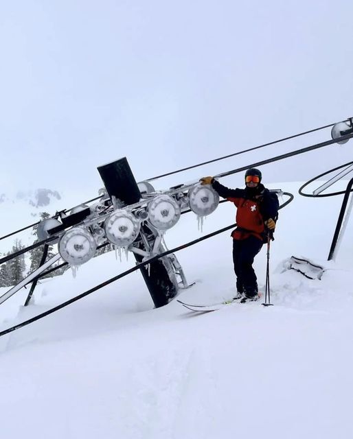
Kirkwood Mountain Resort
The result of 648 inches of snow has led to some extreme shoveling under their ski lift.
They have 233” inches of snow, and this photo went viral as their Tower 8 of The Koala Lift had snow all the way to the top!
This winter was a fail for too little snow for the Eastern US and Too MUCH snow in the western US. We can still get a little snow into April, but I am not holding my breath. Basically, I am ready to move on to the season in place now! Spring!
I own my defeat and honestly am not happy about it for a few reasons. I don’t like to let you down, my kids down, or myself. I am sad all the kids I have visited in schools this year have not had a chance to play like a normal winter.
Dare I make a ‘guess’ for next winter?
It will snow MORE, because it can’t snow less!
If I can laugh at this, I hope you can as well.
Winter History: Low Snow And Late Starts
See my research based on Baltimore data since 1883.

I am aware there are some spelling and grammar typos, and occasional other glitches. I take responsibility for my mistakes, and even the computer glitches I may miss.
I have made a few public statements over the years, but if you are new here you may have missed it:
I have dyslexia, and found out during my second year at Cornell University. It didn’t stop me from getting my meteorology degree, and being first to get the AMS CBM in the Baltimore/Washington region. One of my professors told me that I had made it that far without knowing, and to not let it be a crutch going forward. That was Mark Wysocki and he was absolutely correct!
I do miss my mistakes in my own proofreading. The autocorrect spell check on my computer sometimes does an injustice to make it worse. I also can make mistakes in forecasting. No one is perfect predicting the future.
All of the maps and information are accurate. The ‘wordy’ stuff can get sticky.
There has been no editor that can check my work when I needed it and have it ready to send out in a newsworthy timeline. Barbara Werner is a member of the web team that helps me maintain this site. She has taken it upon herself to edit typos, when she is able. That could be AFTER you read this.
I accept this and perhaps proves what you read is really from me…
It’s part of my charm.
#FITF
Click to see more and ‘Book’ a visit to your school

