


Winter Weather
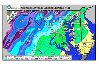
Maryland Snow
Winter can be broken down into two main categories of weather. How much snow will fall the temperatures impacted by mountains or water. Snow in Maryland really highlights multiple climate zones across a small area.
Learn More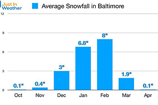
Baltimore Snow History
The ‘average’ of 20 inches is a three decade average between 1980 to 2010.
Learn More
History of FITF and December 5th Snow
December 5th 2001 was a day the record high temperature, December 5th 2002 the record snowfall of 7.4″ was measured at the BWI. ONE YEAR LATER!
Read More
NOAA Winter Weather Maps
Weather Precipitation Center, Storm Prediction Center, and National Hurricane Center
Learn More
NWS Snow & Ice Forecasts
The area National Weather Service Offices put out a product that displays potential snowfall for an upcoming event
Learn MoreMaryland Emergency Vehicle Tracker
Make your morning commute easier by tracking which roads the snow plows are out on.
View Here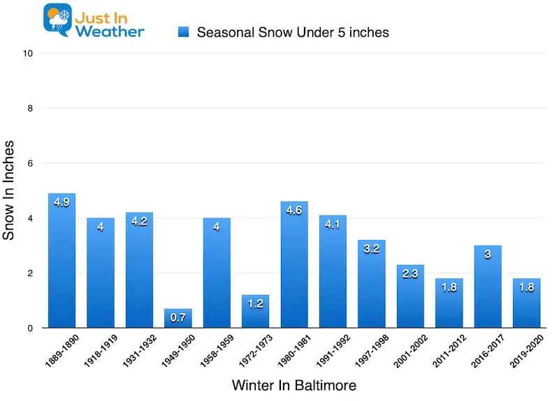
Low Snow Winters
Since winter weather records began in 1883, Baltimore has NEVER had a winter void of snow.
Learn More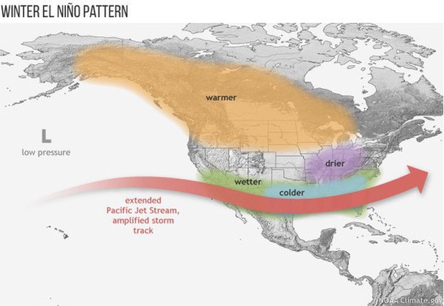
El Nino Winters
A stormy pattern across the southern US that can turn into Nor’easters for us.
Learn More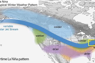
La Nina Winters
The storm track from the Pacific Ocean tends to take a northern route, diving across the central plains, then up the Ohio Valley.
Learn More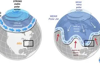
Global Patterns & Forecasts
Long Wave Cycles are global scale weather patterns. These are observed higher in the atmosphere at jet stream level.
Learn More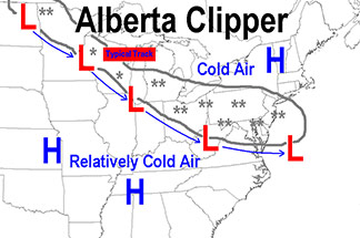
Winter Storm Types
Snow events in the winter can arrive in the Mid Atlantic region in many ways
Learn More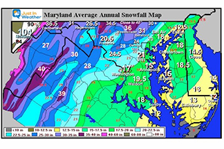
State Snow Region
Note: Snow along the boarder of southern PA with northern Maryland, they don’t match!
Learn More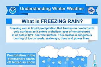
Winter Precipitation
Winter precipitation can best be described as a variation of frozen ‘stuff’ falling from the clouds.
Learn More
Live Roadside Footage
Click on a camera on the interactive map to view a live roadway and assess current conditions.
View HereLive Updates

FITF APPAREL

Winter Weather
Winter weather in and around Baltimore Maryland and the Mid Atlantic can be widely variable in our region. It can range from mild with low snow in some years, to blockbuster storms producing feet of snow. Those historically come from large coastal storms called Nor'easters.
What makes forecasting much more complicated is our geography in the Mid Atlantic, especially in Maryland. The ocean to our east can supply moisture, but supply warm (above freezing) air to storm. That can mix snow to sleet, and a chilly rain. We also see the influence of the Chesapeake Bay warming nearby areas.
To the west, the Piedmont hills lead to rugged mountains between 2,000 and 3,000 Feet high. A few peaks in West Virginia top 4,000 Feet. Temperatures are cooler in the higher terrain on average 3 to 5 degrees cooler per every 1,000 Feet up. But ridges can also help direct storms, block moisture, and even provide warm dry air when the winds blow directly down, creating a rain or show shadow effect.
Just about every big city in the Mid Atlantic and New England has I-95 running through it. This was built on the Fall Line, operating the coastal plain from the Piedmont foothills. This often acts as a boundary for the influence of warmer air east, and more snow just west. Thus making a snow forecast in the most densely populated part of the region most complicated. It is possible to have 6" or more of snow in a storm in one area contrasted with just rain simply 30 to 50 miles away.
I hope the resources on this page can help you track the winter weather and history with ease.
